Setting the Record Straight on Highland’s Drilling in the Porkies

Houghton, Michigan – Those who’ve been following the problems created by Highland Copper Company (Orvana Minerals) exploratory drilling in and around the Porcupine Mountains Wilderness State Park (“Porkies”) earlier this year may have noticed a recent flurry of media stories featuring the mining company’s officials, touting their purported remediation of land along the County Road 519 (CR-519) right-of-way. After churning up more than half a mile of snowmobile trail paralleling the road, the company went silent on the issue until recently, when they presented a new, and largely fictionalized version of what happened last spring, and the environmental damage that resulted in the Michigan Department of Environmental Quality (DEQ) halting Highland’s drilling activity on April 4.

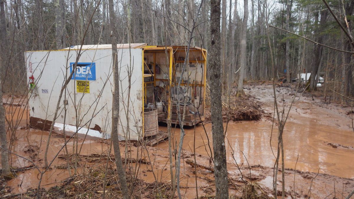
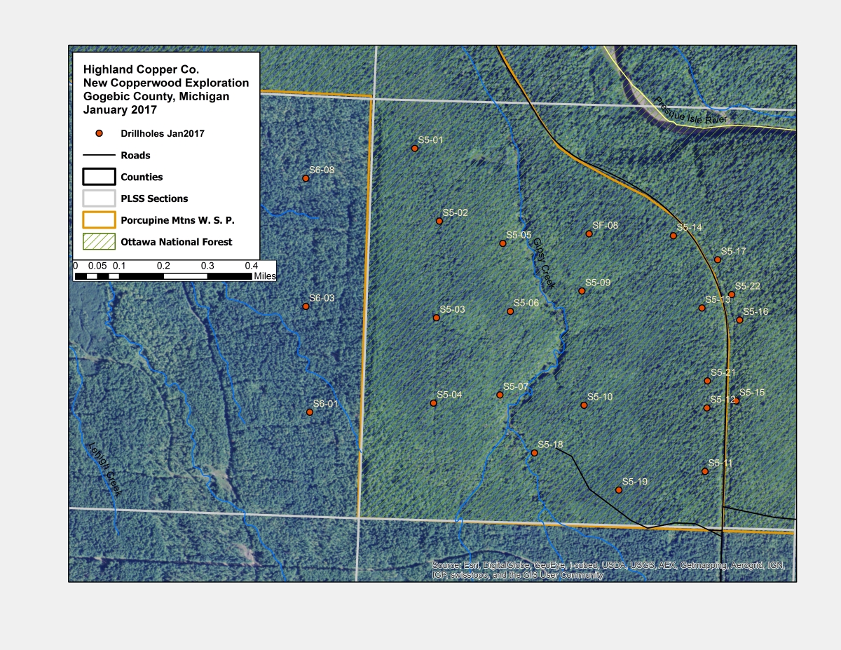
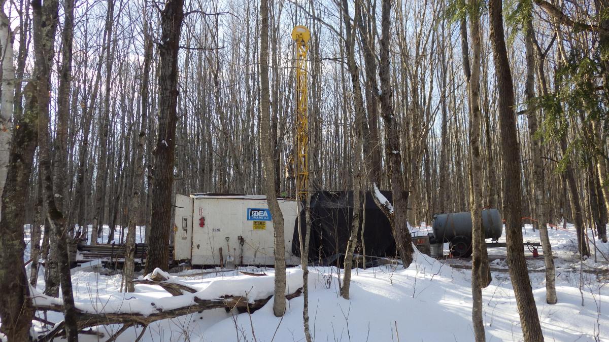
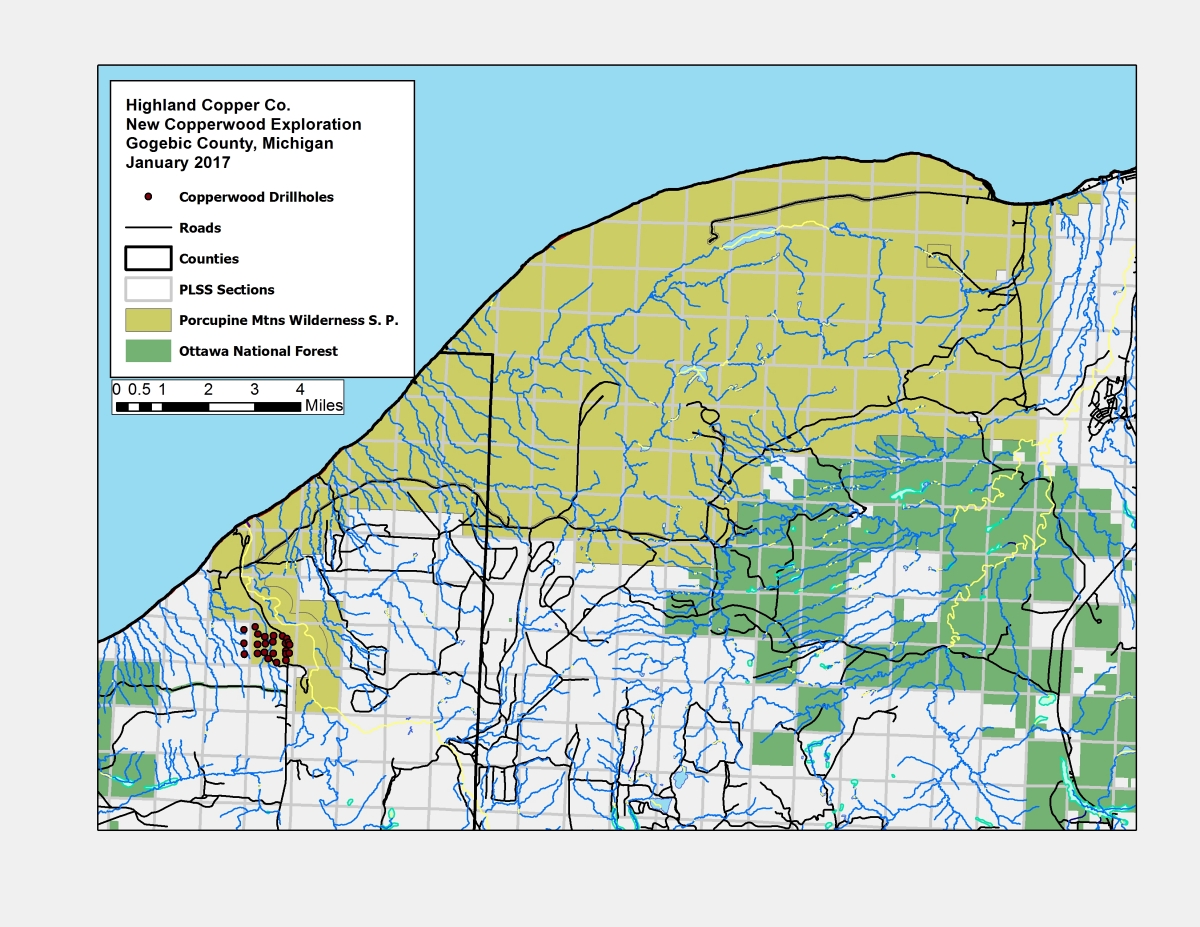
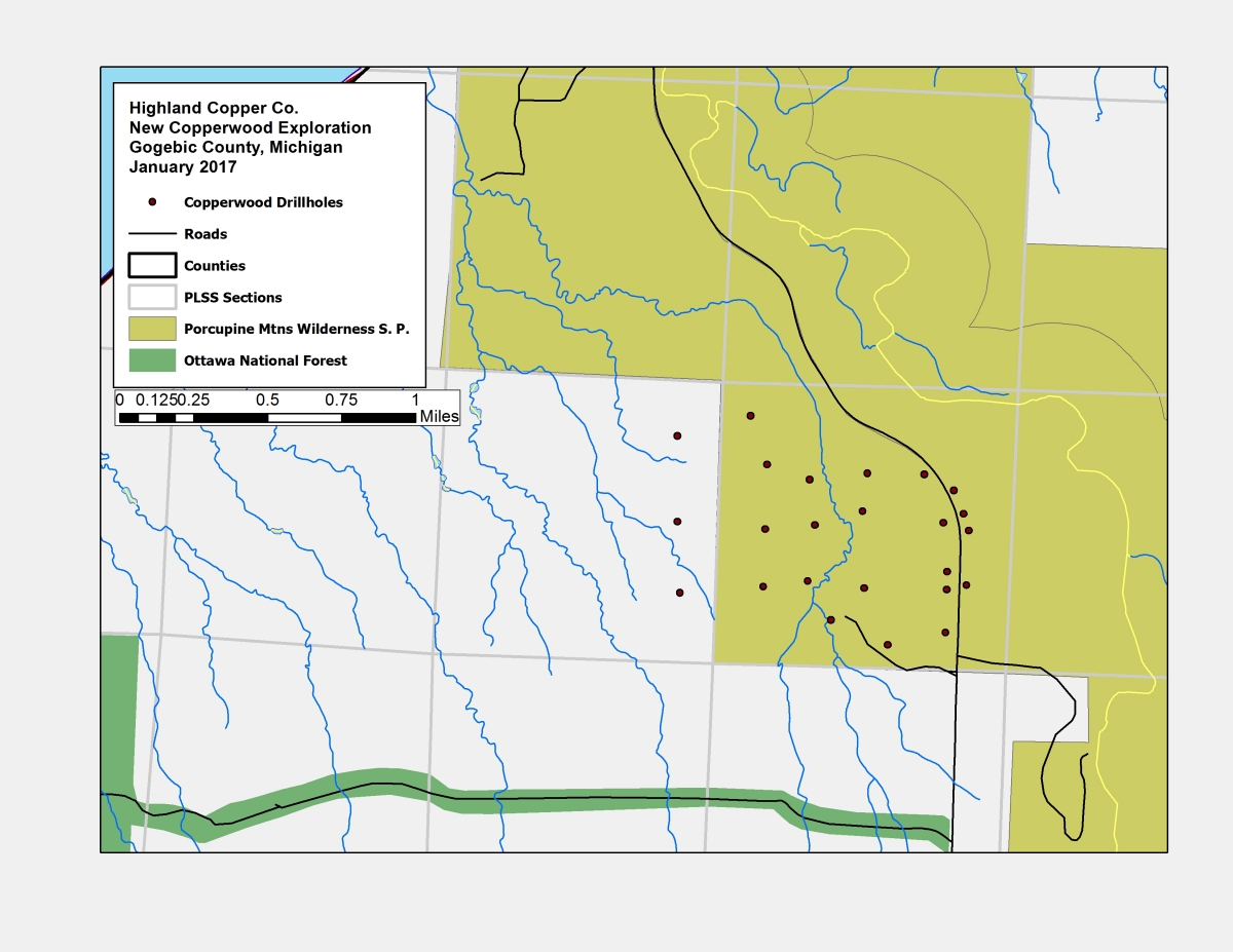
Highland’s problems arose soon after they began drilling within the Park itself, on February 5th. Unseasonably warm weather forced the company to end drilling in the Park in late February, as required by their agreement with the Michigan Department of Natural Resources (DNR). Instead of halting *all* drilling in the area until conditions (thawing snow cover) improved – potentially delaying Highland’s exploration work for another year – the company charged ahead, and began drilling on a narrow strip of land along CR-519. This 466 foot “right of way” (233 feet from the center line in each direction) is owned by Gogebic County, although a legal description includes the east side of the right-of-way within the Presque Isle River Scenic area.

Highland’s contractor kept drilling for over two weeks, even as the warm spell continued.  “What was the company thinking?” asked Horst Schmidt, president of the Upper Peninsula Environmental Coalition (UPEC). “Anybody could see that conditions had deteriorated. Highland’s drilling should have been stopped much sooner.”

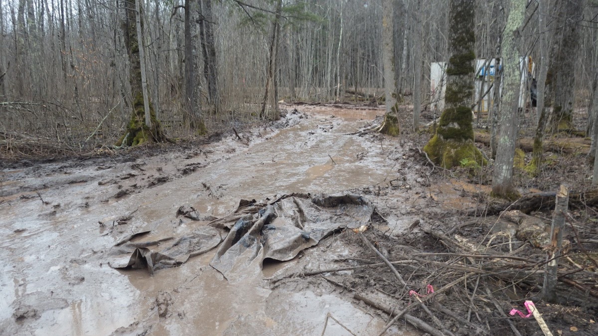
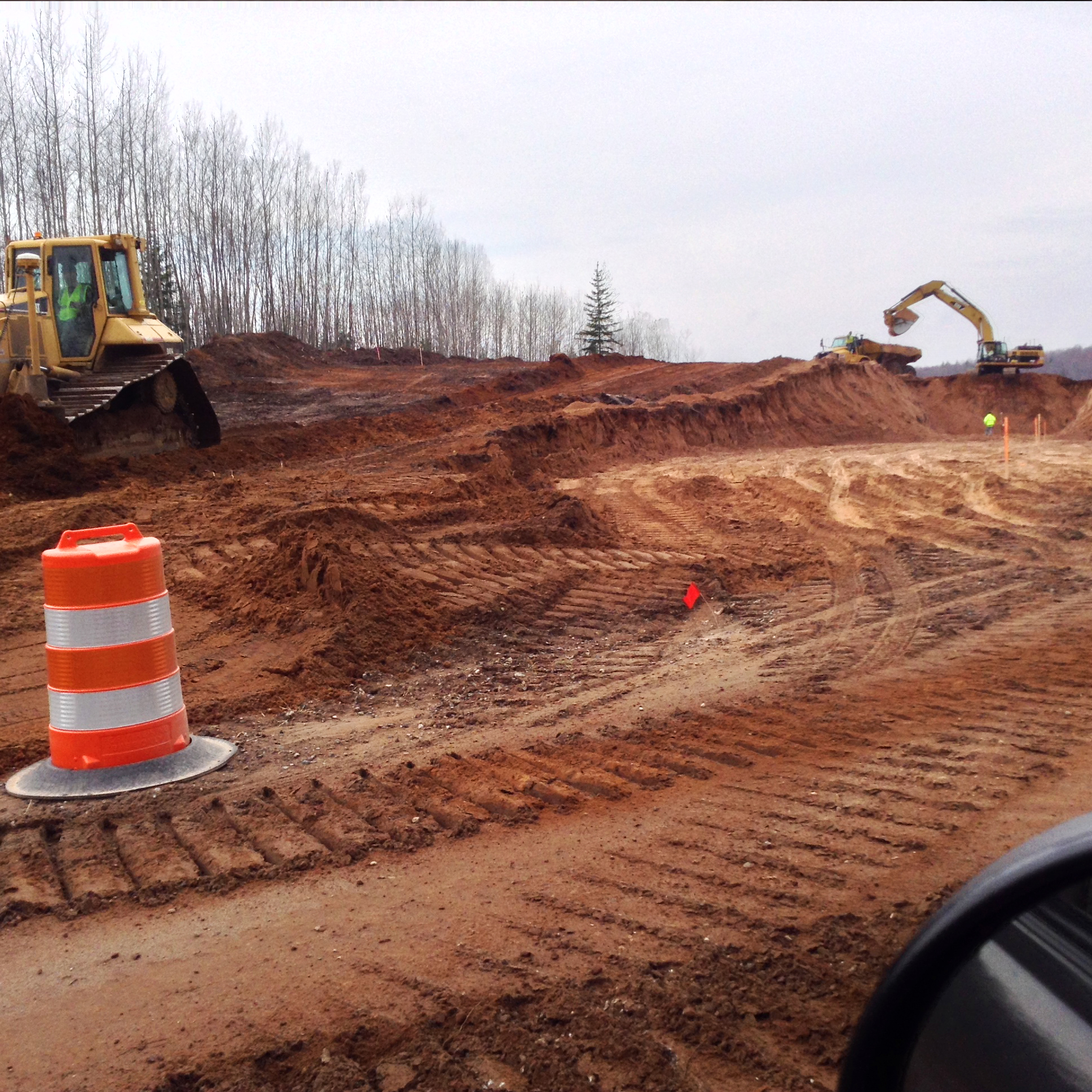
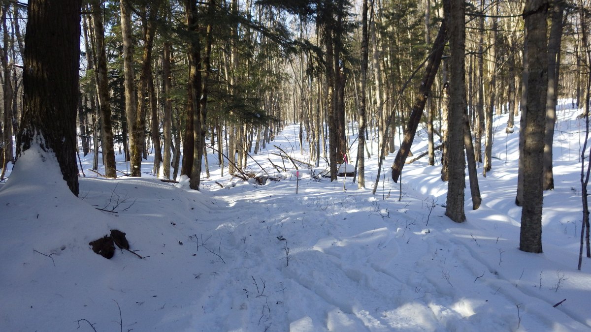
In late March temperatures climbed into the 40’s and 50’s. The snowmobile trail used to access drilling sites on the east side of CR-519 soon thawed, and was churned into mud soup. Only after the heavy equipment sank several feet into the muck did the company admit that spring had arrived. The facts, damages, and the dates are undisputed.

Highland Copper’s most recent press conference presented company officials as clueless regarding the location or extent of wetlands, and unable to discern that the ground was thawing. Snowmobilers gave up and gravel roads were weight-restricted for spring breakup, but Highland continued drilling into early April.

The drilling stopped only after concerned citizens from the UPEC Mining Action Group (MAG) published a press release, documented the environmental damages, and shared the photographs on their website. MAG’s alarming photographs of the damage were quickly picked up by the media, and brought to the attention of the Michigan DEQ. The DEQ promptly sent staff from the Marquette office to the site on Tuesday, April 4. The company was required to suspend work that day, and soon after were issued a Violation Notice by the DEQ.


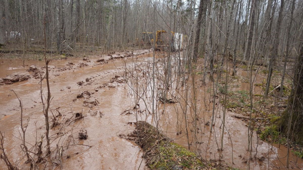
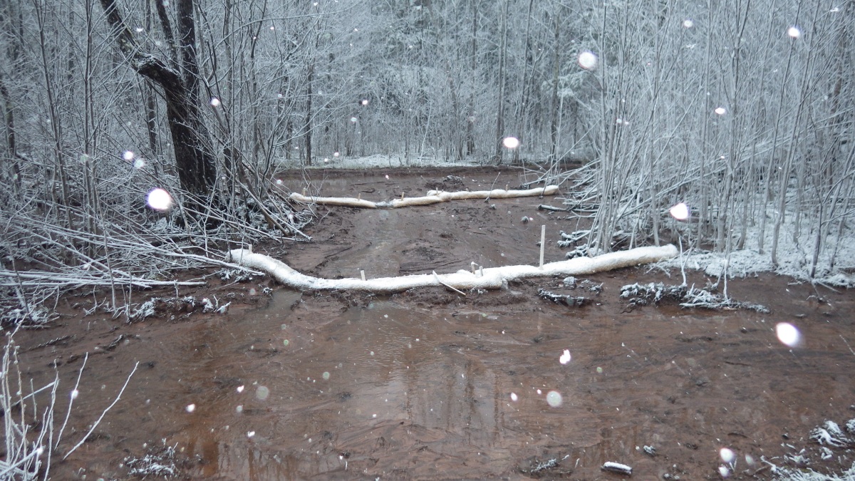
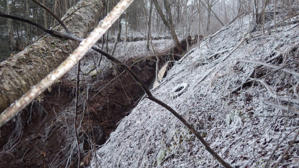
Highland now maintains they didn’t anticipate the spring warm-up, and didn’t know that much of the land was wetland until they received a report from their consultant, King & McGregor. Meanwhile they turned  ½ mile of snowmobile trail into a muddy mess. April 2, 2017.

During their recent media event, Highland Copper’s Vice President of Project Development, Carlos Bertoni, said “When we were drilling here in the spring, early April, the weather became much warmer than we expected.” This is an unbelievable assertion, given that the spring thaw began more than a month earlier.

Bertoni also stated, “Myself as a geologist I could not tell you what is wetland and what is not wetland,” The claim that Highland did not realize they were severely damaging the land until their consultant (King & McGregor) completed a report pointing out that sections of the trail crossed wetlands is also not credible.

“Don’t you think they should be required to hire consultants before they drill?” asked UPEC board member Nancy Warren, who had also been monitoring the site. Neither the company nor the DEQ made any mention of the King & McGregor report at the time.

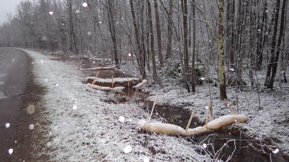
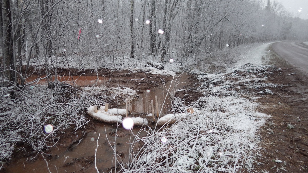
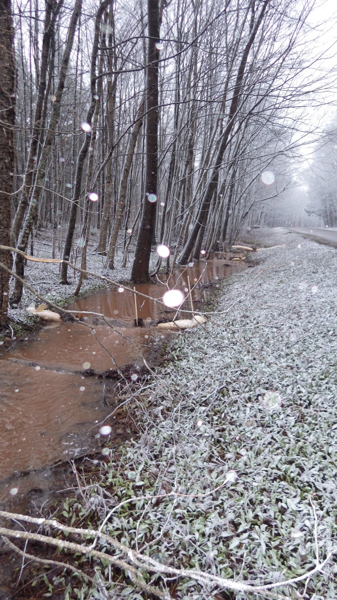
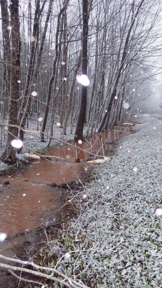
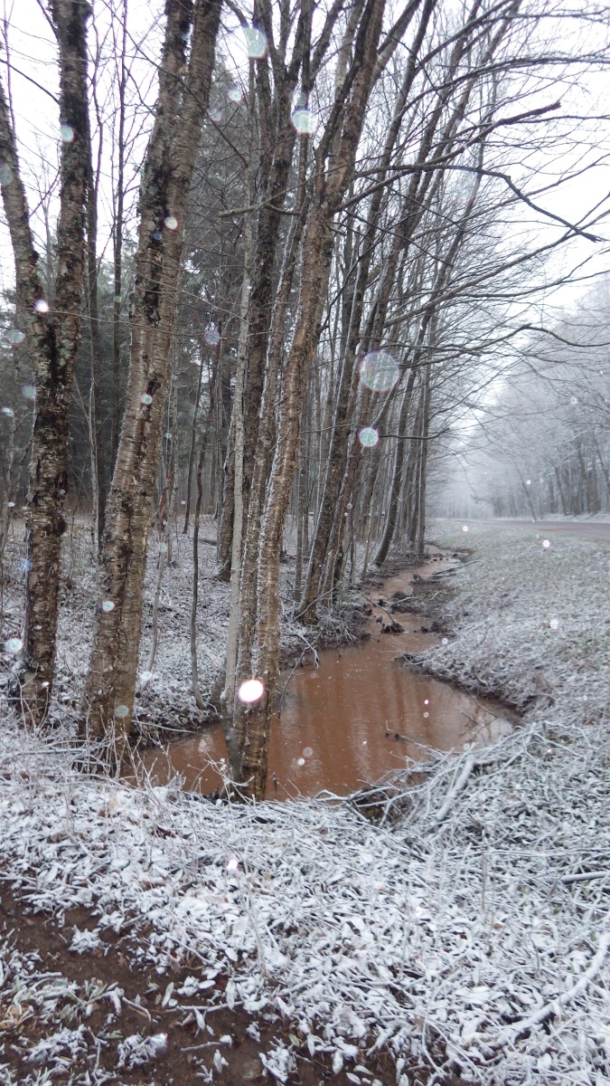
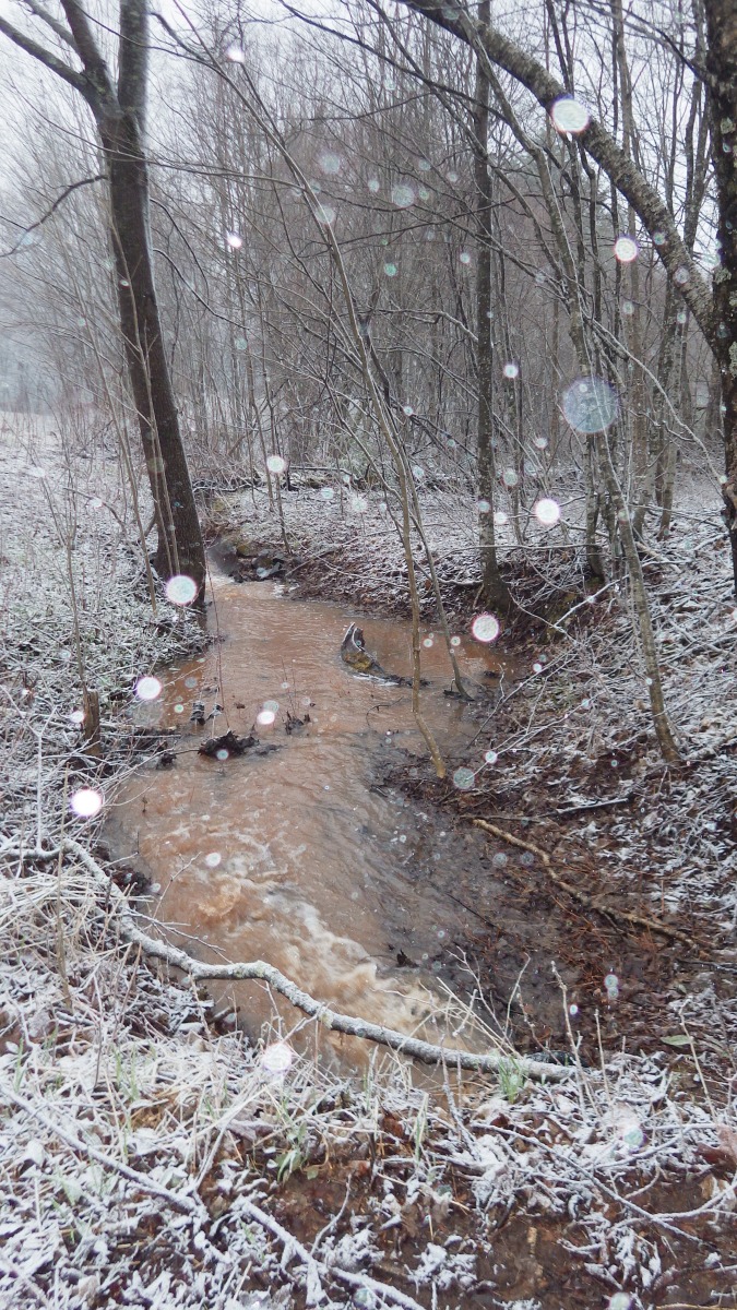
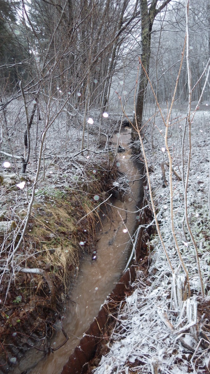
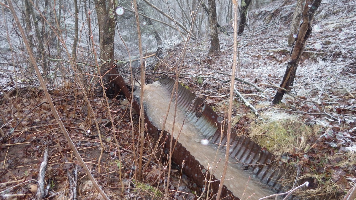
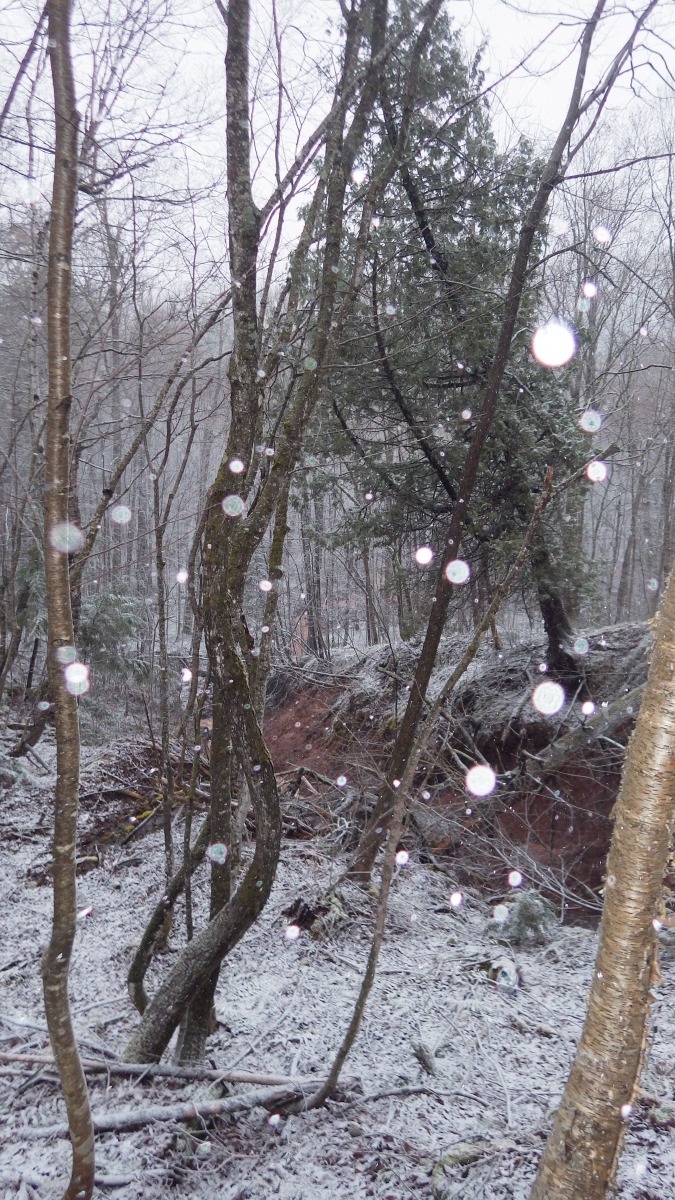
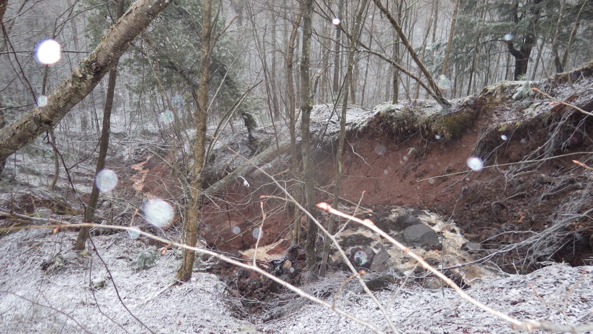
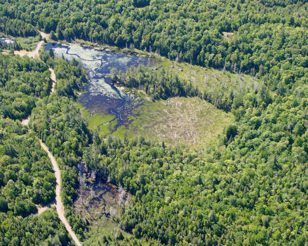
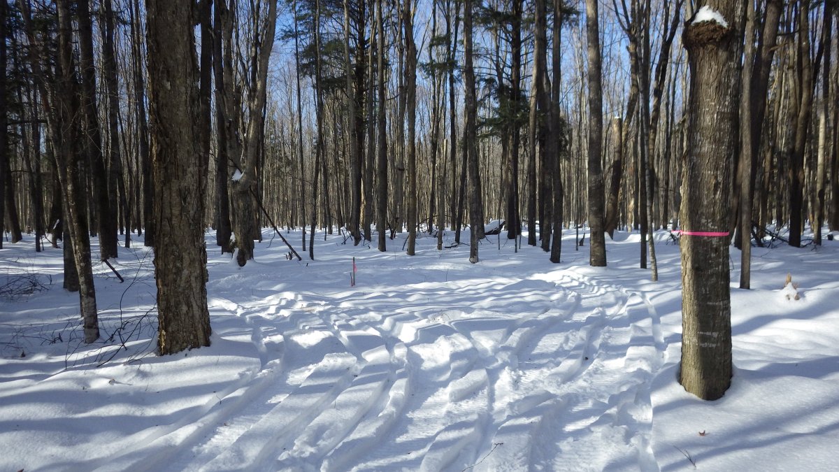
Now, five months after sediment eroded into protected wetlands and mud flowed down the ditches, what is the status of the company’s environmental remediation effort? First they threw straw bales and bundles into the ditch to slow down the flow of water.  Then they smoothed out the ruts and seeded English rye grass (not “native plants” as Bertoni claimed). The damage is still clearly visible along the trail as well as away from the road. Mud that ran north along the ditch and off the site last spring ended up on the floodplain of the Presque Isle River.


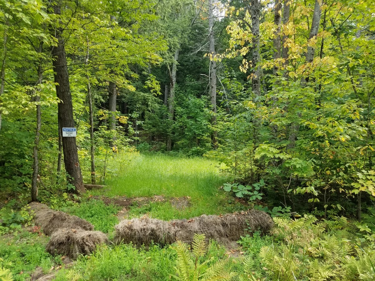
Five months later, the site has been stabilized. The trail (behind the hay bales) has been seeded with English rye grass, and native plants are slowly re-establishing on their own. September 3, 2017.


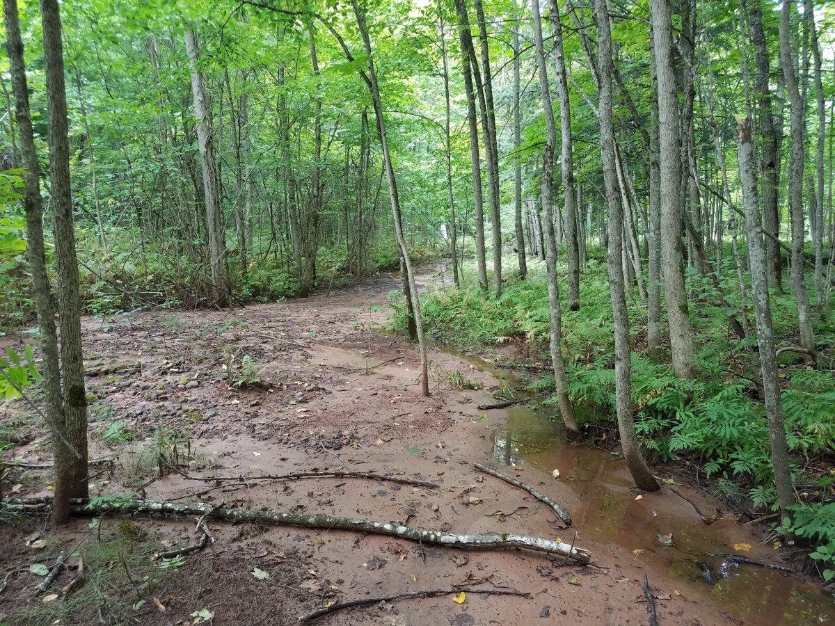
The company was cited for allowing muddy runoff to reach Gipsy Creek, on the southern end of drilling site. However, much of the mud flowed north along the ditch and down the wide ravine of the Presque Isle River, where it was deposited on the floodplain within the Park. Since the growing season is ending, this area continues to be susceptible to erosion going into winter. September 3, 2017

Why are MAG environmentalists concerned about a seemingly minor incident at the far western end of the Porkies? If Highland Copper (or their contractors) will not do the right thing when they think no one is watching, what will happen when they actually start mining? Since their Copperwood mine project sits on the shore of Lake Superior, the stakes are extremely high. Highland is already talking about mining not only next to, but underneath the Porcupine Mountains Wilderness State Park, which makes the project exponentially more risky.

In their original joint press release, the DNR and DEQ failed to acknowledge the critical importance of citizen vigilance in this situation. “I’m outraged that volunteer activists from the Mining Action Group were never recognized for monitoring Highland’s irresponsible drilling activities and documenting the damages to Michigan’s natural resources. I strongly feel that the vital watchdog role played by concerned citizens — environmentalists, not the state  — must not be scrubbed from the official record.” said Kathleen Heideman, UPEC board member and a member of the Mining Action Group (MAG).

“Highland’s actions are highly irresponsible. If they are going to make this much of a mess at such an early stage in the project, how can we expect them to mine responsibly? If they can’t even be bothered to pay attention to the condition of the land around them, how can we trust them to not pollute Lake Superior? Carelessness is not a culture that will change overnight, and this incident makes it appear that Highland has developed a culture of carelessness,” said Nathan Frischkorn, a 2017 Fellow working with the Mining Action Group.

“This incident shows once again that mining companies are so interested in appearances and retaining complete control that when forced to act, they may go so far as to fabricate their own stories.” said UPEC president Horst Schmidt.

RELATED NEWS STORIES

Smithsonian Magazine (February 17, 2017)
http://www.smithsonianmag.com/smart-news/mining-exploration-begins-michigans-porcupine-mountains-180962108/

Michigan Department of Natural Resources (April 6, 2017)
State agencies addressing erosion concerns at Porcupine Mountains
https://content.govdelivery.com/accounts/MIDNR/bulletins/192acad

Keweenaw Now (May 12, 2017)
DEQ cites Highland Copper’s wetlands, soil erosion violations from mining exploration in Porkies, along CR 519
http://keweenawnow.blogspot.com/2017/05/deq-cites-highland-coppers-wetlands.html

UP Matters.com (August 8, 2017)
http://www.upmatters.com/news/ local-news/highland-copper- company-provides- rehabilitation-work-update-on- county-road-519/785568630

ABC News 10 (August 9, 2017)
Exploratory drilling rehabilitation efforts underway
https://abc10up.com/2017/08/09/exploratory-drilling-rehabilitation-efforts-underway/

Fox News TV 6 Marquette (August 9, 2017)
http://www.uppermichiganssource.com/content/news/Highland-Copper-rehabilitating-wetlands-in-the-Porcupine-Mountains-439515913.html

The Daily Mining Gazette (August 11, 2017)
Drilling Fix Media Show: Gazette not invited to mine company’s unveiling of drill damage repair within park
http://www.mininggazette.com/news/2017/08/drilling-fix-media-show-gazette-not-invited-to-mine-companys-unveiling-of-drill-damage-repair-within-park/

Should Michigan lease 15,000+ acres of minerals to Eagle Mine?

Friends, another critical public comment period came to a close this weekend – concerning this outrageous mineral lease request from Eagle Mine targeting public lands in four counties —Baraga, Houghton, Iron and Marquette –  in Michigan’s Upper Peninsula:

“Eagle Mine LLC, of Champion, Michigan, has requested direct development metallic minerals leases from the State of Michigan covering Department of Natural Resources (DNR) metallic mineral rights located within T47N R34W, T47N R35W, T51N R30W, and T51N R31W, located in Baraga County; also T47N R35W and T47N R36W, located in Houghton County; also T46N R34W and T46N R35W, located in Iron County; and T50N R28W, located in Marquette County, containing a total of 15,274.27 acres, more or less.”

Our concerns with Eagle Mine’s alarming environmental record are well known. In reviewing these lease nominations, the Mining Action Group also identified problems with the DNR’s public process, and broad concerns about the scope of the proposed leases, the trend of increasing mineral exploration targeting public lands, and the specific threats posed to natural resources (water quality risks, habitat disruptions, industrial land uses incompatible with land management goals, etc.). On behalf of our supporters, advisors, and other concerned citizens, we submitted extensive written comments to the Michigan Department of Natural Resources.

Conclusions:

Some of these state-protected and federally-owned public lands should absolutely not be leased. We believe that the landscape-scale expansion of mineral leasing and exploration is not the best or most desirable land use, and the stipulations and restrictions provided are insufficient to protect natural resources. As environmental stakeholders, we have identified several opportunities for process reform related to the DNR’s duty to inform the public of proposed Mineral Leases, and better safeguard the Public Trust.

Specific Requests:

  • We strongly urge the Department of Natural Resources to deny the mineral lease sought by Eagle Mine LLC for 40 acres of State-owned land on the Yellow Dog Plains (T50N R28W, Marquette County).
  • For parcels having stipulations of “Threatened or Endangered Species Habitat”, The DNR should consult its own records, the Michigan Natural Features Inventory database, and/or the Ottawa National Forest data to find out what state- or federally-list rare species are known to occur on these lands. The DNR should then consider whether mineral exploration on these lands has a significant chance of damaging or destroying any existing populations of these species. If so, the mineral rights beneath these parcels should NOT be leased for mineral exploration. Additionally, all of these parcels should be reconsidered in terms of the potential impacts to critical habitat for newly listed Endangered species, such as the Northern Long-Eared Bat (and protection of hibernacula) and the Rusty Patched Bumble Bee.
  • For mineral leases within the Wild and Scenic corridor of the Ontonagon River, we recommend no mineral leases be issued (deferring to federal protection of surface resources). These include parcels in T47N, R36W, Sections 9, 15, 23, 25, 26, 35 and 36.
  • Downstream from these lease requests, the East Branch of the Ontonagon becomes a designated National Wild River. If leases are considered, they must be re-evaluated in terms of the federal restriction of “1/4 mi on each side of designated Wild and Scenic and Recreational rivers.” Land within this corridor has special protection. Strongest protection is for for Wild Rivers, where federal mineral rights are withdrawn. Water quality within this segment is also strictly protected.
  • We strongly object to the proposed mineral leases that are partly or entirely within lands being considered for inclusion in the National Wild & Scenic River system. This includes parcels T47N, R34W Sections 9, 10, 15, 16, 22, 26, 27, 28, and 35, which fall partly or entirely within the National Wild and Scenic River study area for the Net River. We ask that the DNR defer to the federal study process and deny leases to mineral rights under these lands.
  • The DNR should consult with its own biologists and with Ottawa National Forest biologists and land managers before leasing any of the other parcels under these public lands.
  • Land management plans for forest units on state lands in these counties should be updated to accurately reflect the widening threats of mineral exploration and changing land use.

In closing, we repeat the statement made by the DNR’s Brian Roell, concerning the unexamined cumulative impacts of mineral leasing and the fact that “present and anticipated increase of mining exploration activity in this area could individually and/or cumulatively adversely impact the long-term viability of various wildlife populations in this region.” When and how will the DNR tally the cumulative environmental impacts of these pending mineral lease decisions? In our opinion, leasing decisions are made in a predictable and piecemeal fashion, disregarding obvious trends and cumulative impacts to natural resources. The current proposal to lease more than 15,000 acres of State forest land to a single mining company is staggeringly short-sighted, and if approved will further undermine our Public Lands and jeopardize Michigan’s long-term stewardship of public forest land, public access, clean water, sustainable forestry, and protective management of Michigan’s wildlife and fisheries. ALL of the proposed leases should be re-examined with an eye to the protection of wild lands, wild rivers, scientific study sites, and critical habitat, both known and potential, necessary for threatened and endangered species.”

Review

Download this file (PDF)


Eagle East Public Comments

The public comment period on the proposed Eagle East permit amendment came to a close at 5pm today. The Mining Action Group hosted two public comment workshops on Tuesday to help guide people through the process of crafting and submitting public comments. We thank everyone who submitted public comments and voiced their concern about this incomplete and misleading permit amendment application.

Our conclusion:
“We believe the Eagle East amendment application does not meet the requirements of Part 632. The applicant has provided an incomplete analysis of the proposed project’s cumulative Environmental Impacts. The proposed amendment attempts to circumvent Part 632’s environmental protections in connecting two distinctly different orebodies through a single mining permit, which deliberately masks, underestimates or fails to consider the project’s cumulative environmental impacts. The proposed amendment also fails to insure that additional mining will not “pollute, impair, or destroy the air, water or other natural resources or the public trust in these resources” as required by Part 632.

We formally request that the Michigan Department of Environmental Quality reject the proposed Eagle East amendment request and attached EIA as misleading and technically inadequate, and because permit segmentation is being used in order to secure a new mining permit without full consideration of the environmental impacts. We are concerned that the Eagle East review has divided public consideration of the mining (jobs) from the most negative environmental impacts (waste, and further degradations of the Middle Branch of the Escanaba River, caused by industrial wastewater discharges).”

You can read MAG’s full public comments on the Eagle East permit amendment request here.

ACTION ALERT – DIVEST FROM AQUILA’S BACK FORTY PROJECT!

TELL INVESTORS THIS PROPOSED OPEN PIT SULFIDE MINE NEXT TO THE MENOMINEE RIVER HAS NO “SOCIAL LICENSE TO OPERATE”

Aquila Resources has proposed a large open pit sulfide mine a mere 150 feet from the Menominee River (a major Lake Michigan tributary which forms the Wisconsin-Michigan border and flows into Green Bay). The mine footprint is located on the original tribal homeland of the Menominee Indian Tribe of Wisconsin. The tribe is concerned about pollution of the Menominee River and the destruction of sacred sites.

TAKE ACTION — Send a letter to the main financial investors in the Back Forty proposed mine letting them know that this project faces growing opposition* in Wisconsin and Michigan and does not have a “social license to operate.” According to mining risk analysts like Ernst & Young, the fourth greatest risk to mining investors comes from “ignoring community voices and their environmental and public health concerns.”

Send letters to the principal investors in the Back Forty project:

Mr. Oskar Lewnowski, CIO
Orion Mine Finance Group
1121 Avenue of the Americas, Suite 3000
New York, NY 10036

Candace Brule, Investor Relations
HUDBAY
25 York Street, Suite 800
Toronto, Ontario M5J 2V5
Canada
Email: investor.relations@hudbaymminerals.com

Ruffer
80 Victoria Street
London SW1E 5JL
United Kingdom

* Growing opposition as indicated by resolutions against the proposed mine by local units of government, including Marinette County, Brown County, the cities of Peshtigo and Marinette and the towns of Wagner and Porterfield in Wisconsin. Tribal governments that have passed resolutions against the mine include the Menominee Indian Tribe of Wisconsin, the Oneida Tribe of Wisconsin, the Bad River Ojibwe Tribe of Wisconsin, the Keweenaw Bay Indian Community of Michigan, the Pokagon Band of Potawatomi,the Saginaw Chippewa Tribe and the Chippewa Ottawa Resource Authority of Michigan. American Rivers, a national conservation organization has listed the Menominee River as one of the 10 most endangered rivers due to the threat from sulfide mining”.

Open Letter to Orion Mine Finance Group by Al Gedicks

July 5, 2017

Mr. Oskar Lewnowski, CIO
Orion Mine Finance Group
1211 Avenue of the Americas
Suite 3000
New York, NY 10036

Dear Mr. Lewnowski,

I am once again writing in regard to Orion’s 19% investment in Aquila Resources’ Back 40 metallic sulfide project in Michigan’s Upper Peninsula. Local and statewide
opposition to this project has grown considerably since my last update (November, 2016) and should be of great concern to your shareholders.

While Aquila now has three of the four permits for the project it still does not have the support of the people and communities that may be adversely affected by pollution from the proposed mine, including the Menominee Indian Tribe of Wisconsin, that has filed a petition for a contested case hearing challenging the Michigan Department of Environmental Quality’s (DEQ) approval of the mining permit.

Since my last update several counties and townships downstream from the proposed mine have joined the Marinette County Board in passing resolutions urging the Michigan DEQ to deny permission for the mine. These include Brown and Menominee Counties in Wisconsin, the City of Peshtigo in Wisconsin, and the Towns of Porterfield and Wagner in Wisconsin. Door County in Wisconsin will be considering a resolution against the proposed mine at their next meeting. The headline from WeAreGreenBay.com (June 23, 2017) sums up the political sentiment succinctly: “Northeast Wisconsin county leaders making resolutions to condemn Back 40 Mine.”

In addition to the counties and townships opposed to the mine, there are ten tribal governments in Wisconsin and Michigan that have passed resolutions against the project. Seven intertribal organizations, including the National Congress of American Indians (NCAI), have also passed resolutions against the mine. The NCAI has promised to assist the Menominee Tribe to oppose the mine “through media exposure, governmental relations, and to support a call for Congressional oversight hearings to highlight the trust, policy and statutory responsibilities of federal agencies in these matters.”

The April 2017 designation of the Menominee River as one of the 10 most endangered rivers by the national conservation group, American Rivers, has given national visibility to local protests against the mine in Menominee, Michigan and Marinette, Wisconsin. In
announcing the designation of the Menominee River, American Rivers noted that “the proposed mine would pose a significant threat to the cultural and natural resources of the Upper Peninsula, Wisconsin and the Great Lakes Region. Groundwater, rivers and ultimately Lake Michigan would become contaminated if acid mine drainage were to seep into surface and groundwater, posing a significant danger to fish and other aquatic life.”

If you have been reading the press releases from Aquila celebrating the progress of the permitting process, you may be surprised to learn that opposition to the project has been steadily growing to the point where Joe Maki, the head of the DEQ’s mining division has refused to participate in informational meetings before the Menominee and Marinette City Councils because he would rather avoid “a potentially hostile environment” (Penny Mullins, “City council hears mine talk,” Eagle-Herald, June 12, 2017). I have provided a sampling of the news coverage in this packet to document this political reality.

You may dismiss this growing opposition as irrelevant because Joe Maki has stated that public opposition will have no impact upon the mine permit decision. As long as Aquila meets the conditions of the permit requirements, they will be granted permission to mine.

As I pointed out in my last update, this perception is at odds with the growing realization within the mining industry that a social license to operate (SLO) “is an essential part of operating within democratic jurisdictions, as without popular support it is unlikely that agencies from elected governments will willingly grant operational permits or licenses” (Fraser Institute, “What is the Social Licence to Operate (SLO)?” 2012).

As early as 2003, Business for Social Responsibility warned investors “that where there was well-organized, significant opposition to a mining project, no matter their country or political stripe and no matter the prevailing laws, politicians were reluctant to go against
it. In fact, global companies are under greater pressure to respond to broader social expectations today, regardless of the prevailing legal structure, than at any other time in recent history.” (“The Social License to Operate” San Francisco, CA).

Once again, I urge you to review the extensive documentation of community opposition in this packet and make your own judgment about whether this project has a social license to operate.

Sincerely,

Al Gedicks, Executive Secretary
Wisconsin Resources Protection Council

Public Comment Period Extended for Eagle East

“Never doubt that a small group of thoughtful, committed citizens can change the world; indeed, it’s the only thing that ever has.”  – Margaret Mead

Friends,

ACTION ALERT! Tell the Michigan Department of Environmental Quality exactly what you think of Lundin Mining’s requested amendment of the Eagle Mine permit — which would require building more than 8 KILOMETERS of NEW tunnels to reach a totally DIFFERENT orebody, called “Eagle East.”

Eagle East is a new orebody located beyond the previously permitted project boundary for the Eagle Mine. This major expansion could have serious environmental impacts that were never considered under the original permit. More mining will mean more tailings, more dewatering, and increased risk of contamination. Read the proposed Eagle East permit amendment for yourself!

QUESTIONS YOU SHOULD ASK ABOUT EAGLE EAST

1.) Lundin Mining claims the life of Eagle Mine will be extended only 1 or 2 years by extracting the Eagle East deposit. Is it worth the environmental impact to the beloved Yellow Dog Plains, or the Salmon Trout, Yellow Dog and Escanaba Rivers? Eagle East will result in increased hauling, air pollution emissions, tailings waste problems for Humboldt Mill,  and increased discharge of pollutants to the Middle Branch of the Escanaba River.

2.) Lundin describes the combined ore as “Eagle ore” but Eagle and Eagle East are different orebodies, born from different volcanogenic sources. The new Eagle East orebody contains higher grades of copper and nickel, as well as other toxic heavy metals. These metals can be extremely dangerous for aquatic life, headwater streams, and wetlands. Were these threats taken into account in the initial environmental impact assessment, or does this represent a significant change from the original permit?

3.) The Eagle East orebody is located three thousand feet below the surface, much deeper than Eagle, so the ore contains high quantities of entrapped salts from ancient brines. These salts will create long term problems for Lundin’s Humboldt Pit, where the addition of Eagle East tailings are expected to nearly fill the pit with waste, dramatically increasing Total Dissolved Solids. Eagle’s wastewater treatment plant will also need a new crystallizer.

4.) Mining experts have repeatedly warned that the Eagle orebody is filled with hard-to-map “smaller-scale discontinuities that could weaken the rock mass.” Last year’s undisclosed underground “collapse” at Eagle Mine throws the overall safety of the mine’s expansion into question. Has Eagle Mine’s stability been dangerously overestimated from the beginning? Are you concerned about last year’s rock failure at Eagle Mine?

Please let the DEQ know that you want ALL of these serious questions thoroughly reviewed and resolved, before the Eagle Mine permit amendment is considered.

The DEQ has extended the public comment period to July 20th, instead of the previous July 6th deadline. Following the federal holiday for the 4th of July, we will share more details about Eagle East and the environmental impacts, citing specific concerns.

SUBMIT WRITTEN COMMENTS! Public comment on the proposed permit amendment will be accepted until 5 PM on Thursday, July 20th, 2017.
Send all comments to DEQ-Mining-Comments@michigan.gov or mail them to:

DEQ Eagle East Permit Amendment
Office of Oil, Gas, and Minerals
1504 West Washington Street
Marquette, MI 49855

Caption: Industrialization of the Yellow Dog Plains? Eagle Mine’s environmental footprint expands with Eagle East exploration — far beyond the original mining permit. This aerial photograph shows (1) Eagle Mine facility, and active drill rigs in the (2) southern drilling area for Eagle East (3) northern drilling area for Eagle East and (4) eastern drilling area for Eagle East. * The general location of the Eagle East orebody, some 3000 feet below the surface, is outlined by the large circle. May 2017, photograph by Jeremiah Eagle Eye.

Finally, please support our work – even a small contribution makes a big difference.

Onward,
Kathleen Heideman, MAG/UPEC Board Member

Links:
Lundin Mining Corp – Cover for Application to Amend Mine Permit MP012007
Lundin Mining Corp – Mining Permit Application Amendment (Volume I)
Lundin Mining Corp – Environmental Impact Assessment (Volume II)
Lundin Mining Annual Mining and Reclamation Report on Eagle Mine 2016
Michigan’s Part 632 Nonferrous Metallic Mining Regulations

Note: the active Eagle Mine permit, and the original Environmental Impact Assessments, are now available through the DEQ’s ftp server, under
Geowebface > Mining > Eagle Project.
Follow these instructions to log into Geowebface:
http://www.michigan.gov/documents/deq/DEQ_FTP_372266_7.pdf

Eagle Mine Buries Underground Collapse

Marquette, MI — Concerned citizens are publishing the details of an underground collapse incident at Eagle Mine, citing grave concerns with the company’s lack of transparency. The revelations follow several “Eagle Mine Community Meetings” in which the company failed to disclose the details of a significant incident that happened in 2016.

“I attended Eagle Mine’s meeting anticipating some honest discussion of their 2016 underground collapse. Instead, they demonstrated how to use a virtual fire extinguisher to fight a virtual fire. Their 2016 safety review mentioned only medical incidents: a contractor who fell from a ladder and sprained an ankle, an employee who experienced a heart attack, etcetera. Eagle claims that ‘providing transparent information is important to the way we do business,’ but Eagle Mine’s behaviour is anything but transparent,” said Jeffery Loman, Keweenaw Bay Indian Community tribal member and former federal oil regulator.

“Representatives of Eagle Mine failed to address the collapse until they were asked by a concerned citizen at a community meeting in Big Bay, at which point they tried to claim it was an insignificant and harmless incident,” said Nathan Frischkorn, a resident of Marquette.

“Eagle Mine’s failure to disclose a serious underground collapse is outrageous, in light of their request for more permits to expand mining into the new Eagle East orebody. Permitting hinges on public accountability. At the same time, Eagle Mine wants to remove more ore from the very highest levels of the Eagle Mine – a move which experts have long warned could cause the mine’s ceiling or ‘Crown Pillar’ to cave in,” said Kathleen Heideman, Upper Peninsula Environmental Coalition (UPEC) board member and a member of the Mining Action Group.

RUMORS SURFACE

Rumors of the underground collapse at Eagle Mine first surfaced in fall of 2016, when a story circulated that some “mine contractors” had quit over an underground incident they felt was “dangerous.” Responding to the direct question “Was there a partial pillar collapse?” Eagle Mine confirmed that an incident had taken place, but did not use the term “collapse” and provided only a few details:

“In early August, there was a fall of ground incident that occurred during a routine blast in an active stope. The fall of ground occurred due to an unidentifiable natural horizontal feature that failed during a blast, causing a section of ore to fall. Eagle Mine safety standards require all employees to be on the surface during a blast, therefore no employees were underground or at risk at the time of the incident. The situation was identified by employees during the post-blast inspection. Eagle Mine notified the Mine Safety and Health Administration (MSHA) who conducted an investigation.  MSHA notification is required whenever an unplanned fall of ground occurs at or above the anchorage zone in active workings where roof bolts are in use.”

Documents received in May of 2017 from the federal MSHA via a Freedom of Information (FOIA) request filed by a local concerned citizen make it clear: the unplanned “fall of ground” was a significant “large block failure.”

  • Eagle Mine’s Wilhelm Greuer told the MSHA investigator, “this was a wake up call.”
  • A large portion of an underground stope unexpectedly collapsed. The mining term used by the company is an “unexpected fall of ground.” It was described by MSHA  inspector as a “substantial” event, and could have happened at any time.
  • While it is true that no one was working in the drift below the stope when it collapsed, a crew of Cementation employees had been installing rock bolts into the stope prior to the collapse. It could have been a fatal accident.
  • The “unidentifiable natural horizontal feature that failed” (as described by Eagle Mine) was actually a fault, a critical fracture or flaw within the orebody. Was it truly unidentifiable – or simply unidentified? The geological fault or crack ran diagonally through stope 1485 on level 215, which is a “secondary” stope (unit or compartment of ore) contained between two primary stopes, which were already mined out and backfilled. A large quantity of ore below the fracture collapsed without warning. Mining experts describe these fractures as “rock discontinuities” and have warned that the Eagle orebody is filled with hard-to-map “smaller-scale discontinuities that could weaken the rock mass.”
  • The blast that “triggered” the collapse actually took place elsewhere in the mine, in another stope. Eagle said the collapse took place in an “active” stope, but it was not targeted for blasting when it collapsed.
  • The stope dimensions were approximately 33 feet wide by 80 feet high. A working access drift (tunnel) had been widened to the full width of the stope, further destabilizing the ore block. MSHA’s report states “the back broke approximately 9 meters (30 feet) above the existing 20 foot cable bolts.”
  • According to the MSHA investigation, the bolts that were installed “represented approximately one-quarter of the capacity” that was actually necessary for supporting the ore block.

CONCLUSIONS

Alarmingly, MSHA concluded that “because the planar discontinuity (…) was unanticipated, and the failure block was too large to support with a reasonable bolting system, it must be assumed that similar discontinuities could be encountered, any time.”  For greater stability, MSHA recommended leaving ribs of ore in place between stopes to increase safety: “rib pillars should be left in place in secondary stopes to provide physical, standing support.” According to Parker, this mining method was recommended from the beginning. Why was this common sense safety practice (leaving ribs for better support) not done? Simply put, the company did not want leave behind valuable ore. Full-stope mining means taking everything – leaving no ore behind.

While questions were raised about the integrity of cemented backfill, MSHA concluded “this event is not considered a backfill failure issue.” In the wake of the incident, however, several changes were made to Eagle Mine’s backfill regime: changing the cement recipe, heating water before adding it to cement, and even the method of cement placement. Edges of backfilled stopes were found to contain voids and loose material, which may have further contributed to the instability of the ore block.

It is not clear whether MSHA’s recommendations were suggestions or requirements, or whether Eagle Mine has modified their mining practices to avoid future unexpected collapses.

“Criminally defective decisions made by the Michigan’s Department of Natural Resources and Department of Environmental Quality (DEQ) caused the permit to be issued despite obvious and serious legal and technical shortcomings. Eagle Mine’s permits were built upon false design and false data provided by amateur consultants who blatantly fabricated numbers, maps and sections which are in no way representative of the conditions in and around the orebody. The mine owners and their consultants still share responsibility for these errors, some of them life-threatening, all of them jail-worthy,” said Jack Parker, a veteran miner and mining consultant.

“Lundin and the Eagle Mine management have demonstrated to the general public what we have known all along: they will withhold information from the public if it might be damaging to their image. Lundin could have disclosed this information at the Eagle Mine forums held last fall or last week. They chose not to,” said Gene Champagne of Concerned Citizens of Big Bay.

“It is incomprehensible why Lundin would widen the access drift below the stope without providing additional support. The MSHA report indicates that the affected area was only 28% supported. Greed is indeed a powerful force. This was not the fault of some overactive employee trying to impress the bosses and become employee of the month, as suggested by Matt Johnson’s comment in the Big Bay meeting. Someone gave the order to widen that stope. The public needs to know who. This was an accident waiting to happen and possibly could have happened without a blast occurring and while our working neighbors and relatives were still underground,” said Champagne.

EAGLE WANTS TO TAKE MORE ORE

Prior to the collapse, Eagle Mine submitted a stability report to the MDEQ, seeking to revise the mine’s critical “Crown Pillar” design. Lundin wants to extract an additional two levels of ore from the top of the orebody. The Michigan DEQ reviewed and quietly granted their request, with no opportunity for public comment. Reports were made available only recently, after a request made by the Upper Peninsula Environmental Stakeholders Group.

Lundin Mining acknowledges in their most recent Technical Report on Eagle Mine that “due to the location of the mine under a significant wetlands area and overburden cover, a crown pillar is necessary for the Eagle Mine to prevent surface subsidence and/or large-scale collapse.” The precise thickness and strength of the mine’s “crown pillar” or rock roof has been a hotly debated issue for more than a decade. Several mining engineers, after examining drill cores and rock quality data, have concluded that Eagle Mine’s design is fundamentally unstable, based upon flawed or falsified stability data. Some stated under oath that a crown pillar less than 300 feet thick would be likely to collapse. Eagle Mine, with DEQ’s approval, has now thinned the crown pillar from 287 to only 95 feet, in order to extract more ore.

“Eagle’s secretive behavior, in the wake of the collapse, is alarming. Is Eagle Mine stable, as the company insists, or will unmapped faults prove catastrophic, as experts have warned? Nobody wants to see a serious collapse at Eagle Mine. That would devastate the headwaters of the Salmon Trout River, directly above the mine,” said Alexandra Maxwell, Yellow Dog Watershed Preserve administrator.

“No one in the Upper Peninsula should feel comfortable about the planned activities at Eagle until the financial responsibility assurances required by government regulators are at least an order of magnitude greater than what they are today,” said Loman.

“In light of last year’s significant underground collapse, which was hushed-up and passed off as a minor fall of ground incident, an independent professional review of the Eagle Mine’s data and design is needed. Ultimately, the Michigan DEQ must take steps to correct this unfortunate situation and forestall others. Mining of the Eagle East orebody must not be permitted until Eagle Mine’s design and rock data finally pass muster,” said Parker.

MORE INFO

“The analysis techniques used to assess the Eagle crown pillar stability do not reflect industry best-practice. In addition, the hydrologic stability of the crown pillar has not been considered. Therefore, the conclusions made within the Eagle Project Mining Permit Application regarding crown pillar subsidence are not considered to be defensible.”
– David Sainsbury


“A discrete sub-vertical fault plane that intersects the Eagle deposit has not been considered in any of the stability or subsidence analyses.”

– Sainsbury


“…the possibility of complete crown pillar failure should be a serious concern.”

– Sainsbury

COVERAGE

Copper Drilling Makes Mess of Porcupine Mountains Wilderness

UPDATED on May 1, 2017:   Porkies Drilling, Mud on the Move? new site photographs taken by the UPEC Mining Action Group on April 26th. 

April 26, 2017:  sediment-filled muddy water is seen passing through fiber rolls (erosion control) on an access road left chewed up by drilling equipment. Muddy water is flowing into ditches of CR-519, which convey the water to a ravine which feeds Presque Isle River.

Michigan DNR public information officer John Pepin has defended the drilling activity, and “compared the use permit the agency granted Highland Copper to what the DNR would give someone wanting to use state land for a wedding.”

Houghton, MI — As warmer weather melts the blanket of snow and the ground below, exploratory copper drilling in Porcupine Mountains Wilderness State Park (widely known as “the Porkies”) in the northwoods of Michigan’s Upper Peninsula continues. The result is a big muddy mess, and potential violations of the state’s Natural Resources and Environmental Protection Act, Act 451 of 1994 (NREPA).

“It looks like hell – far worse than I was expecting,” said Steve Garske, UPEC board member. “Considering the exceptional natural and recreational features threatened by this drilling activity, it simply amazes me that the DNR is sitting on their hands and doing nothing.

Photographs taken on April 2, 2017 document extensive damage caused by the use of heavy equipment in Porcupine Mountains Wilderness State Park, by Orvana Resources and their contractor, Idea Drilling. For additional geotagged photos, see: http://bit.ly/2oCh7JX

In February, the Michigan Department of Natural Resources (DNR) issued a surface use permit authorizing Orvana Resources – a subsidiary of Highland Copper – to begin exploratory drilling in the Porkies. The company contracted to do the work is Idea Drilling of Minnesota. The DNR has defended their surface use agreement and the company’s “Environmental Management Plan” as “protective” in press releases and interviews, touting the use of the “least impactful”routes to access drill hole sites, and claiming that drilling would be done in the winter months “to reduce and limit compaction and erosion impacts to soils.”

In its broadly-worded management plan, Orvana promised to follow strict guidelines guaranteed to protect the Porkies from the destruction of public resources, old growth forest, soil erosion and other damage to the land. They claimed that “Wetlands and hydric soils will be avoided” and that “All activities will adhere to the MDNR and MDEQ Sustainable Soil and Water Quality Practices on Forest Land (February, 2009 revision)”. Despite these reassurances, members of the Upper Peninsula Environmental Coalition (UPEC) now report that Orvana’s exploratory drilling work has turned the site into an ugly, mile-long mudhole.

The Porcupine Mountains Wilderness State Park is an all-season draw for the region, well known for its hiking trails, rugged terrain, old growth forests, miles of wild and scenic Lake Superior shoreline, wilderness campsites, rivers, lakes and waterfalls. The “Porkies” have been featured as a premier hiking destination by Backpacker Magazine, USA Today, and other national media. Widely considered the crown jewel of Michigan’s state park system, it is one of the most popular tourist destinations in the midwest. The park is prominently featured in the PURE MICHIGAN tourism campaign: “Undisturbed on the edge of Michigan is an untamed world of uncharted woods and unseen stars…” Visitors are urged to “Come to the Porcupine Mountains (…) and see nature in its purest form.” (See “Pure Michigan’s Porcupine Mountains: Call of the Wild”).

While the Porcupine Mountains Wilderness land is owned by the State of Michigan, County Road 519 is managed by the Gogebic County Road Commission, which issued a permit in February for drilling activity to take place within the “Right of Way” (ROW). That permit states that Orvana must “RESTORE ALL DISTURBED AREAS BACK TO EXISTING CONDITIONS”, a condition that, given the severe rutting and damage, now seems impossible.

According to DNR spokesman John Pepin, Orvana’s management plan only applies to the 12 drill holes that are on State Park land but outside the 466-foot county right-of-way. Yet the plan is carefully worded so that it seems to provide protection to the lands within the right-of-way as well. A subsequent DNR press release (February 23, 2017 – see link below) misleadingly implied that the company would be suspending drilling in the park, stating that “Highland Copper hopes to resume its exploration of the minerals – which are not owned by the State of Michigan – should prolonged wintry conditions return soon to Gogebic County“ and that “The company plans to reassess the situation in a couple of weeks. If exploration is not resumed in March, the drilling program will be postponed until next winter.”

The February 23 press release gave no indication that the company would return to drill in the CR-519 right-of-way during spring break-up, without regard for ground conditions or how much damage they would do. However, a March 15 press release (see link below) quotes Pepin as stating that “This work today does not restart Highland Copper’s exploratory work on park land situated west of County Road 519” and that “Barring a significant return to wintry conditions, there is not expected to be any additional borings on state park land this winter.”

Given the overlapping layers of jurisdiction – mineral rights, surface use agreements, and right-of-way access, it is unclear whether the DNR will enforce any of the provisions of the Environmental Management Plan. According to Doug Welker, former UPEC board member, the DNR has neglected to enforce stipulations in the state’s Wilderness and Natural Areas law (Part 351) which prohibit mineral exploration in designated State Natural Areas. “Drilling within the Presque Isle River Scenic Site is in conflict with State law,” said Welker.

The land east of the road where the most severe damage has been done is part of the Porcupine Mountains’ Presque Isle River Scenic Site, according to Welker. “The legal boundary of the Scenic Site is the road itself, not the east boundary of the right-of-way, according to a rule within the Michigan Administrative Code. The Presque Isle River Scenic Site is a legally-dedicated State Natural Area, and exploration for or extraction of minerals is prohibited in State Natural Areas according to Michigan law (NREPA).”

“Every citizen should be disgusted by the environmental damage being caused by the mineral exploration underway at the Porcupine Wilderness State Park,” said UPEC president Horst Schmidt.

“Although the DNR said Highland Copper would minimize any harm to natural features in the park, the pictures clearly contradict those claims. The DNR needs to stop further exploration drilling while it clarifies the legal status of drilling on State Natural and Wilderness Areas and other protected areas, as required by NREPA Part 351, 324.35102: ‘Wilderness, wild, and natural areas; duty of department to identify, dedicate, and administer.’ We ask the DNR to conduct a thorough investigation of its legal duty on behalf of our wilderness and natural areas,” said Horst.

“If we can’t trust Highland Copper to behave responsibly and take adequate precautions at drilling sites, and if we can’t trust the State to make sure that they do, why should we believe that Highland and the State will act responsibly if mining takes place?” asked Welker.

According to the senior planning team at the Superior Watershed Partnership, “The proposed Porcupine Mountains project seems to ignore sound science, environmental ethics and common sense. The risk is simply too great for groundwater, surface water, Lake Superior and this unique wilderness park.”

“I’ve seen industrial-scale pig farms that made less mud than Highland’s drilling – and this is happening in a State Natural Area! Drilling activity using heavy equipment during spring thaw churns the forest floor into flowing mud, and threatens water quality in nearby streams, rivers and lakes, including Lake Superior. It seems obvious that severe impairment and destruction of our natural resources is taking place. The DNR needs to act quickly to protect our natural resources and the public trust,” said Kathleen Heideman, UPEC board member.

In allowing exploratory drilling in the Porkies, and failing to monitor and regulate the resulting environmental impacts, the DNR has demonstrated a stunning disregard for the health of the land and the wishes of its citizens. “Those who care about Michigan’s future need to remind state representatives and agencies (in this case the DNR) that they serve the public, not multinational mining companies intent on short-term profits at the state’s expense. This is no way to treat our unique Wilderness park,” notes Garske.

“The ‘public’ in public land seems to have no clout. In our name, public lands can be sold, traded, and drilled, often with little or no public input. Shouldn’t there be tighter restrictions on what can be done in a wilderness state park like the Porkies? Why are we stuck in a legal mindset from the 1880s that allows “reasonable” mining exploration in areas where such activity, from a 21st century perspective, is entirely unreasonable?” asked historian Jon Saari, a UPEC Board member.

“The damage and the aggressive nature of these test drilling has to be first stopped, and then understood. No one is doing that,” said Pat Egan, conservation chair of the Three lakes Sierra Group in the Upper Peninsula of Michigan. “The DNR has an obligation, as stewards of the state park, to protect the surface and the commonly owned natural assets of that park. We don’t know if there is permanent damage; as yet, no one does.”

“As people begin thinking about spring and summer camping in the state’s largest and arguably most beautiful state park, they need to know that the DNR and the DEQ are protecting their park,” said Egan.


UPDATE – May 1, 2017

Porkies Drilling, Mud on the Move?
photos taken April 26, 2017


What do these photographs show? Why is erosion and sediment control important?  According to the Michigan Department of Environmental Quality’s website: “Sediment is the greatest pollutant by volume impacting our lakes, streams, and wetlands. Sediment is the product of uncontrolled erosion. Everyone in Michigan is affected by erosion and off-site sedimentation. Erosion and sedimentation result in: loss of fertile topsoil, filling of lakes and streams, increased flooding, damage to plant and animal life, and structural damage to buildings and roads. Construction is one of the major causes of erosion in Michigan. Without proper planning and management, over 100 tons of sediment per acre per year can be generated on some construction sites. Why was Part 91 passed? The primary intent of Part 91 is to protect the waters of the state and adjacent properties by minimizing erosion and controlling off-site sedimentation. What activities require a Part 91 permit? A permit is generally required for any earth change that disturbs one or more acres, or is within 500 feet of a lake or stream. Exempted activities include plowing and tilling for crop production and some logging and mining activities. Access roads to the logging and mining sites and ancillary activities associated with logging and mining operations are not exempt.” For more information about erosion and sediment control, see: MDEQ Part 91 SESC FAQs


UPDATE – April 20, 2017
Upper Peninsula Mining Company Cited for Soil Erosion DEQ Press Release

UPDATE – April 7, 2017
Muddy drilling mess at Porcupine Mountains under DEQ investigation published by Garret Ellison for MLive.com on April 7, 2017

UPDATE – April 5, 2017
Muddy Drill Rigs Pulled from Porkies Wilderness – photos taken April 4, 2017


LINKS FOR MEDIA

SUGGESTED CAPTION

“Photographs taken on April 2, 2017 document extensive damage caused by the use of heavy equipment in Porcupine Mountains Wilderness State Park, by Orvana Resources and their contractor, Idea Drilling.” The photos are geotagged, and may be viewed on this Google Map: http://bit.ly/2oCh7JX

RELATED DOCUMENTS


Wall Street Journal Prints ‘Alternative Facts’ By Lawyers Appealing CR-595

Marquette County Road Commission v. Environmental Protection Agency

Regional environmentalists are dismissing as “wildly inaccurate” an article published in the Wall Street Journal (*1) on March 3rd, entitled “How a Michigan County Road Got Stuck in Regulatory Purgatory”. The piece, co-written by two lawyers working on the Marquette County Road Commission (MCRC) lawsuit against the Environmental Protection Agency (EPA) “relied on ‘alternative facts’ and amounted to little more than a highly-placed publicity stunt,” according to Kathleen Heideman, a Board member of the Upper Peninsula Environmental Coalition’s (UPEC) Mining Action Group.

The Wall Street Journal story plays fast and loose with the facts, according to Heideman, suggesting that the road proposal is a “shovel-ready” jobs initiative caught in “regulatory purgatory” and that the EPA was “vague” in their wetland objections, which ultimately “vetoed” a critical road building project.

In fact, the mine’s original (permitted) transportation plan matches the mine’s current haul route, and the “short cut” was only concocted after the mining company purchased the Humboldt Mill property for processing and refining their ore. The so-called “shovel ready” plan failed to clear the review of multiple federal agencies, including EPA, the U. S. Army Corps of Engineers, and the U. S. Fish and Wildlife Service. Previously, the mining company told regulators that they would use “existing infrastructure” and develop a rail depot north of the city of Marquette. “Groggy college students” would not have been endangered by Eagle Mine’s original plan.

“REGULATORY PURGATORY”?  A FACTUAL HISTORY OF CR-595

From the beginning, environmentalists have contended that the Road Commission was trying to build an industrial road – a mining haul road for the benefit of a single company – rather than a County Road designed to benefit the public. “The Pacific Legal Foundation is attempting to recast this issue as an anti-EPA “states rights” issue, and revising history as they go. The facts of the case simply do not support their claims,” said Steve Garske, UPEC Board member and member of the Mining Action Group.

The CR-595 proposal was controversial from its first incarnation as the privately-funded “Woodland Road” proposal, which the owners of Eagle Mine (then Rio Tinto) offered to fund. Promoters of the “Woodland Road” claimed its main purpose was to provide local citizens with easier access to the roadless interior of Marquette County for hunting, fishing, berry-picking, and other recreational activities, while dodging massive ore trucks. Federal agencies objected to the “Woodland Road” plan on the grounds that impacts to wetlands and streams were poorly quantified, and because the road’s stated purpose was highly inaccurate.

Contrary to the Wall Street Journal article, the objections raised by federal agencies were always quite specific, as seen in early March 2010: “The application must quantify aquatic impacts, especially the following: the loss of headwaters and wetlands associated with headwaters, in each watershed; the loss of rare wetland plant communities, including bogs, fens and wet meadows; and water quality degradation due to runoff containing pollutants, and clearly indicate how the loss of each of these features would be compensated. This is necessary to allow (Michigan environmental regulators) to fully evaluate whether compensation is possible for the unique functions lost within each of the four watersheds… Woodland Road application is deficient in several areas, including reasonable comparison of alternative routes, an adequate 404(b)(1) analysis, and an adequate compensatory mitigation proposal.” (*2)

Remote Mulligan Creek wetlands complex, at the site of the proposed CR-595 crossing, photograph by Amy Cherrette (2016).

Woodland Road was later renamed “County Road 595”; the proposed route would have cut through 22 rivers and streams, including the Dead River and Yellow Dog River Watersheds, Mulligan Creek headwaters, Voelker Creek, and Wildcat Canyon Creek, destroying approximately 25 acres of wetlands, directly impacting 122 wetland complexes, and bisecting a major wildlife corridor, fragmenting both habitat and hydrology.

“The EPA’s decisions were not ‘arbitrary and capricious’ as the Road Commission has contended. Instead, they were in alignment with the concerns of the other state and federal agencies charged with protecting our natural resources,” said concerned citizen Catherine Parker.

Narrow leaved gentian growing at the Mulligan Creek wetlands complex, in the path of the CR-595 project. According to the Michigan Natural Features Inventory, this rare native plant is a threatened species, ranked “S2, meaning imperiled in state because of rarity (6 to 20 occurrences or few remaining individuals or acres) or because of some factor(s) making it very vulnerable to extirpation from the state.” Photograph provided by Jeremiah Eagle Eye.


In 2012, when the EPA objected to the project’s failure to avoid or minimize impacts to wetlands and streams, it gave the MCRC and the Michigan Department of Environmental Quality (DEQ) 30 days to modify their plans. On January 3, 2013, the DEQ announced that it would not be issuing a permit for the project. The implication was that the state regulators simply ran out of time, and the mining company, impatient for a secured haul road, decided to invest in improving the existing route specified in its mining permit.

So Eagle Mine paid for a different seasonal road to be widened and paved as far as the mine’s gate, and plans for CR-595 were abandoned – but not forgotten.

After abandoning the CR-595 proposal, the Marquette County Road Commission “improved” an unpaved, seasonal road to serve as a Haul Route for Eagle Mine. The pavement ends at the gate of the mine. Photograph by Kathleen Heideman (May 2014).


In July 2015, the MCRC filed a lawsuit claiming the EPA had unfairly “blocked” the road’s construction. To be clear, the CR-595 project still could have been built, but wetland permits would need to be secured from the U.S. Army Corps of Engineers. Yet MCRC never applied to the U.S. Army Corps of Engineers for permits to build CR-595. “It seems that Eagle Mine and the Marquette County Road Commission are allergic to federal permits. Certainly they’ve avoided federal oversight at every turn,” said Loman.

MCRC’s lawsuit against the EPA was heard by Federal Judge Robert Holmes Bell in 2016. Judge Bell dismissed the lawsuit, stating that the MCRC “doesn’t have a viable claim against the EPA.” The MCRC appealed, and Judge Bell denied the motion for reconsideration. According to the Pacific Legal Foundation, attorneys and a mediator appointed by the appellate court were to have discussed a possible settlement by phone on March 6. If no resolution was reached, the case will proceed to the 6th U.S. Circuit of Appeals.

According to a federal attorney familiar with the case, such mediation will “address only the pertinent questions of law.” The facts of the case were previously addressed by the lower circuit court, which dismissed the Road Commission’s lawsuit against the EPA as baseless.

JUST THE FACTS

While the Wall Street Journal pairs the story with a photograph of scenic downtown Marquette, Eagle Mine’s trucks do not actually run through downtown Marquette. Those most affected by the mining trucks are local residents along the route which runs along the outskirts of Marquette and other small towns, and the so-called “groggy college students” at Northern Michigan University, where ore trucks and logging trucks pass the north edge of campus.

Save the Wild U.P.’s Summer Fellows at the site of the proposed CR-595 crossing of the Dead River wetlands complex (2015).

“College students are the ones who will inherit this mining mess in a few years — along with the financial responsibility for a thousand other contaminated mine sites, milling sites, and haul routes that haven’t been properly cleaned up. If the Marquette County Road Commission gets its way, these young taxpayers will also be saddled with the cost of constructing and repairing another haul road for Eagle Mine, on top of their college debts,” said Jeffery Loman, Keweenaw Bay Indian Community tribal member and former federal oil regulator.

According to Parker, “MCRC never had a case. Period. The evidence is right there in the files I received through Freedom of Information Act requests.”

“The road proposal was not an environmentally responsible option, and doesn’t fix any of the problems created for our community by the sulfide mining industry. The MCRC’s proposed dredge-and-fill, slash-and-burn method of road construction would produce exponentially more greenhouse gas than would be saved by shortening Eagle Mine’s haul route,” noted Alexandra Maxwell, a UPEC Board member.

The proposed CR-595 road would have destroyed dozens of heavily forested wetlands along the route. According to new research (*3), forested wetlands provide extremely high carbon sequestration benefits, trapping anywhere from 2,750 to 4,100 pounds of carbon per acre per year.

“It is important to remember that any potential benefit to air quality from the shortened trip will be offset by the fact that road construction effectively converts forests into pavement. Construction permanently cuts and burns the surrounding forest, releasing stored carbon dioxide into the atmosphere. Considering CR-595 would be approximately 66 feet wide for 22 miles (applicants stated that habitat removal would be at least 66 feet in width, totaling approx. 180 acres), this is a substantial loss for the climate,” said Emily Whittaker, Special Projects Manager for the Yellow Dog Watershed Preserve, another organization which has vigorously opposed the CR-595 project.

After the CR-595 road proposal was abandoned, the Marquette County Road Commission used slash and burn land-clearing methods to dramatically widen and pave the “Triple A” (a season unpaved road) as far as the gates of Eagle Mine. This photograph shows stumps and roots set on fire, using fuel accelerant, along the route. Photograph provided by Jeremiah Eagle Eye.

“More important than the question of carbon released or sequestered by the construction of a new haul road from mine to mill is the impact of the road itself to an undeveloped region of the Upper Peninsula. This road would be nothing like the ‘Woodland Road’ touted by its proponents. It would be an all-season ribbon of concrete within a wide corridor, a permanent swath fragmenting a sensitive and wild landscape,” remarked Jon Saari, historian and UPEC Board member.

“We should be thankful to the EPA for setting high standards for any big new highway. Our region is still recovering from the wounds of the last mining and logging era a hundred years ago. The Lonely Planet’s Best in Travel 2017 guide (*4) just cited the Upper Peninsula of Michigan as a national treasure for its beaches, waterfalls, small towns, and old forests — in other words its natural setting. The EPA recognized that, too, and showed some backbone in this political and legal fight,” said Saari.

Back in 2012, when the road proposal became mired in wetlands concerns, Michigan lawmakers were quick to make statements of support for the road, which touted short-term jobs to be created by road construction. Michigan’s unemployment rate has fallen sharply since then. But unemployment rates and robust economic development may not be the ultimate value in many residents’ minds. According to the results of a newly published survey by Michigan State University researchers (*5), most Michigan residents — 59% — “favor protecting the environment, even when there could be economic risks of doing so, such as job loss” and they “prioritize the environment over economic growth.”

The environmental threats are real. According to the 2014 report “Status and Trends of Michigan’s Wetlands” (*6), Michigan has lost 40% of its original wetlands since the start of European settlement. While the rate has slowed, wetland losses continue, with 41,000 acres of wetlands lost since 1978. The pressure to sacrifice Michigan wetlands for the sake of poorly-conceived roads or short-lived industrial developments – like CR-595 and Eagle Mine – continues. In requiring the MCRC to prove that a road through the wild heart of Marquette County was needed and would be designed to minimize impacts on the environment, especially wetlands, headwaters and aquatic resources, the EPA was doing its job: protecting our natural resources.

Aerial view of remote Wildcat Canyon Creek wetlands complex and logging trail, site of proposed CR-595 crossing, photograph by Kathleen Heideman (2015).

NOTES

  1. https://www.wsj.com/articles/how-a-michigan-county-road-got-stuck-in-regulation-purgatory-1488585470
  2. Letter dated March 12, 2010 from the U.S. Army Corps of Engineers to EPA Region 5, concerning the Woodland Road proposal.
  3. See: http://researchnews.osu.edu/archive/freshwetlands.htm, authored by Dr. William Mitsch at Ohio State University’s School of Environment and Natural Resources, with support from the U.S. Environmental Protection Agency and the National Science Foundation.
  4. See: Lonely Planet’s Best in Travel 2017 (2016), p. 169.
  5. http://msutoday.msu.edu/news/2017/a-trump-twist-environment-over-economy-in-michigan/
  6. http://www.michigan.gov/documents/deq/DEQ-Water-Wetlands_-Status_and_trends_498644_7.pdf

###

Founded in 1976, the Upper Peninsula Environmental Coalition’s purpose remains unchanged: to protect and maintain the unique environmental qualities of the Upper Peninsula of Michigan by educating the public and acting as a watchdog to industry and government. UPEC is a nonprofit, registered 501(c)(3) organization. For more information, call 906-201-1949, see UPenvironment.org, visit our Facebook page, or contact: upec@upenvironment.org.

The UPEC Mining Action Group (MAG) is a grassroots effort to defend the clean water and wild places of Michigan’s Upper Peninsula from the dangers of sulfide mining – previously known as Save the Wild U.P. (SWUP). Contact the UPEC Mining Action Group at info@savethewildup.org or call (906) 662-9987. Learn more about the Mining Action Group at miningactiongroup.org or follow MAG’s work on Facebook or Twitter.

Drilling in Porcupine Mountains Wilderness Undermines Public Land

Houghton, MI —Upper Peninsula Environmental Coalition (UPEC) members and supporters are expressing outrage and frustration following news that the Michigan Department of Natural Resources (DNR) issued a surface use permit authorizing Orvana Resources – a subsidiary of Highland Copper – to begin exploratory drilling in Porcupine Mountains Wilderness State Park (also called “the Porkies”). According to the DNR, drilling began Sunday — before the agency’s press release had been published.

The Porcupine Mountains Wilderness State Park is well known for its hiking trails, rugged terrain, old growth forests, miles of wild and scenic Lake Superior shoreline, wilderness campsites, rivers, lakes and waterfalls. The Porkies are an all-season tourism draw for the entire region, and have been featured as a premier hiking destination by Backpacker Magazine, USA Today, and other national media.

“The sulfide mining industry is leading the State of Michigan around by a leash. Environmental regulators are completely out of touch with public sentiment on this issue. Michigan residents and visitors from around the country love the Porkies, and are angered by this announcement,” said Kathleen Heideman, a UPEC Board member.

According to DNR spokesman John Pepin, the agency did not provide public notice or a public comment period before issuing a permit for exploratory drilling on January 31.

“Whether this is a violation of Michigan’s open meeting law (Act 267 of 1976) is an open question, but it seems clear that the state has little interest in the public’s opinion concerning exploratory hardrock mineral drilling in Michigan’s premier state park,” said Steve Garske, botanist and Board member of UPEC.

The Porcupine Mountains Wilderness State Park is the crown jewel of Michigan’s state park system and one of the most popular tourist destinations in the midwest. In fact, the park is prominently featured in the PURE MICHIGAN tourism campaign: “Undisturbed on the edge of Michigan is an untamed world of uncharted woods and unseen stars, a magical place overflowing with waterfalls, where the Porcupine Mountains still whisper ancient tales and legends, and the rivers seem to flow into forever – a place known as the Wilds of Michigan, found in the Westernmost corner of the Upper Peninsula. Here we can get back in touch with nature, and back in touch with ourselves.” Visitors are urged to “Come to the Porcupine Mountains (…) and see nature in its purest form.” (Source: “Pure Michigan’s Porcupine Mountains: Call of the Wild”).

“Considering the exceptional natural and recreational features threatened by this decision, why wasn’t there an opportunity for public input?” asked Garske.

The mining of sulfide ore invariably leads to acid mine drainage, which threatens groundwater, streams, rivers and lakes, including Lake Superior.

“The ‘public’ in public land seems to have no clout. In our name, public lands can be sold, traded, and drilled, often with little or no public input. Shouldn’t there be tighter restrictions on what can be done in a wilderness state park like the Porkies? Why are we stuck in a legal mindset from the 1880s that allows “reasonable” mining exploration in areas where such activity, from a 21st century perspective, is entirely unreasonable?” asked historian Jon Saari, a UPEC Board member.

“The DNR’s actions – allowing a mining company to conduct exploration drilling in the Porkies – will outrage a lot of people. And the public should be outraged,” said Alexandra Maxwell, another UPEC board member. “Once again, we see there isn’t a single square inch of Michigan safe from the threat of sulfide mining and exploration – they’re mining under our rivers, drilling in fragile wetlands, drilling on state and national forest lands, and now drilling in the Porcupine Mountains Wilderness State Park.”

In allowing exploratory drilling in the Porkies, DNR has failed to protect Michigan’s natural resources, and demonstrated a stunning disregard for the health of the land and the wishes of its citizens. “It’s up to those who care about Michigan’s future to remind state representatives and agencies (in this case the Michigan DNR) that they serve the public, not multinational mining companies intent on short-term profits at the state’s expense. This is no way to treat our unique Wilderness park,” notes Garske.

Updated 3-16-2017: map of the site including geotagged photographs by Steve Garske


UPDATE – May 1, 2017
Porkies Drilling, Mud on the Move? photos taken April 26, 2017

UPDATE – April 20, 2017
Upper Peninsula Mining Company Cited for Soil Erosion DEQ Press Release

UPDATE – April 7, 2017
Muddy drilling mess at Porcupine Mountains under DEQ investigation published by Garret Ellison for MLive.com on April 7, 2017

UPDATE – April 5, 2017
Muddy Drill Rigs Pulled from Porkies Wilderness – photos taken April 4, 2017

UPDATE – February 12, 2017 – photographs of the site by Steve Garske

Additional files related to Copperwood project (Orvana, Highland Copper)

UPDATE – February 8, 2017 – Michigan DNR spokesman John Pepin stated to TV6 news: “the state does not own the mineral rights and it is not a discretionary decision….” He also said that “Highland Copper notified all local government officials and tribes before exploratory drilling began on Sunday” (but not the public, or environmental stakeholders).

LINKS FOR MEDIA

SUGGESTED CAPTION

“Photographs taken on April 2, 2017 document extensive damage caused by the use of heavy equipment in Porcupine Mountains Wilderness State Park, by Orvana Resources and their contractor, Idea Drilling.” The photos are geotagged, and may be viewed on this Google Map: http://bit.ly/2oCh7JX

RELATED DOCUMENTS

####

Founded in 1976, the Upper Peninsula Environmental Coalition’s purpose remains unchanged: to protect and maintain the unique environmental qualities of the Upper Peninsula of Michigan by educating the public and acting as a watchdog to industry and government. UPEC is a nonprofit, registered 501(c)(3) organization. For more information, call 906-201-1949, see UPenvironment.org, visit our Facebook page, or contact: upec@upenvironment.org.

The UPEC Mining Action Group (MAG) is a grassroots effort to defend the clean water and wild places of Michigan’s Upper Peninsula from the dangers of sulfide mining – previously known as Save the Wild U.P. (SWUP). Contact the UPEC Mining Action Group at info@savethewildup.org or call (906) 662-9987. Learn more about the Mining Action Group at miningactiongroup.org or follow MAG’s work on Facebook or Twitter.